Table of Contents
Tucked away in North Richmond, Yeoman’s Lane is one of those Hawkesbury thoroughfares that tells its story quietly. It is not a main road, nor was it ever intended to be. Instead, Yeoman’s Lane reflects the rural logic of the early Hawkesbury practical, understated, and shaped by the needs of farming families.
In the Hawkesbury, yeoman farmers were the backbone of the local economy, supplying produce to Sydney and supporting generations of families who worked the floodplain and surrounding higher ground.
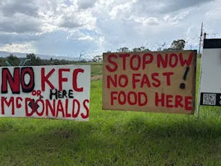
Over time, the economy has changed. Farms have been subdivided, land uses have diversified, and modern infrastructure has crept closer. Colo High School is almost opposite the lane and the paddocks next to the school has recently been sold for future development.
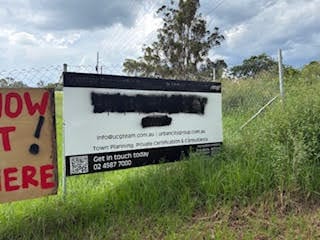
A Development Application proposal for a proposed childcare centre and two fast food outlets was lodged by Urban City Consulting, however this has been superceded by Sutherland & Associates Planning, further a Complying Development Certificate for a Dwelling, Pool & Shed was issued by Urban City Certifying .
The RU1 zoning permits this type of development on the land in question. It is understood that the applicants initially explored building in North Richmond village area but were unable to secure suitable land.
"Hawkesbury Council’s failure over the past decade to deliver an updated Local Environmental Plan (LEP) has created a planning vacuum, increasing the likelihood of ad hoc development wherever land becomes available." says Troy Myers Urban City Consulting.
"As a result, councillors and community are often unable to meaningfully influence planning outcomes."
Explainer: Why Planning Feels “Ad Hoc” in Hawkesbury
Questions about zoning, rural development and housing approvals continue to surface across the Hawkesbury, particularly in Rural Zones such as RU1, RU2 and RU4. Many residents are asking: How did we get here? And why does planning sometimes feel reactive rather than strategic?
The answer lies in how NSW planning law works and where Hawkesbury Council currently stands within that system.
What NSW Law Requires Councils To Do
Under the Environmental Planning and Assessment Act 1979, every NSW council must prepare a Local Strategic Planning Statement (LSPS) a 20-year vision that explains how land use, housing, employment and infrastructure will be managed.
In Hawkesbury, this is the Hawkesbury Local Strategic Planning Statement 2040. It sets broad planning priorities and aligns local objectives with state and regional plans.
Hawkesbury’s operative planning instrument is the Hawkesbury Local Environmental Plan 2012. While amended periodically, it has not undergone a comprehensive update since its introduction more than a decade ago.
Councils must maintain a current Local Environmental Plan (LEP), the legally binding zoning document that determines what can and cannot be built on each parcel of land. LEPs are required to be reviewed every five years to ensure they remain fit for purpose.
What Are “Place Plans”?
In recent years, council has prepared draft “Place Plans” for centres including across the Local Government Area. These documents outline aspirations for built form, heritage protection, village character and public space improvements.
However, place plans are not statutory documents under NSW planning law. They do not change zoning. They do not override the LEP. Instead, they are strategic guides intended to inform future amendments to planning controls.
Until those changes are formally embedded in the LEP or Development Control Plan (DCP), they carry limited legal weight in development assessments.
Hawkesbury Council Place Plans document was criticised for containing inaccurate and misleading information by individual, community and business groups.
The LEP Gap - Why It Matters
Planning experts note that when an LEP becomes outdated, tensions can emerge.
Zoning such as RU2 Rural Landscape may legally permit certain types of development, even if community expectations have evolved. Without an updated LEP reflecting contemporary policy, council assessment staff and, in some cases, the Land and Environment Court must rely on the existing controls.
This can create the perception of “ad hoc” development not because rules don’t exist, but because the rules may no longer reflect current strategic intentions.
In effect, the statutory framework continues operating, but without a refreshed policy foundation.
Who Ultimately Decides?
Contrary to popular belief, councillors do not determine most individual development applications. Elected representatives set strategic policy and planning controls. Day-to-day assessment decisions are typically made by council staff under delegated authority, or by independent panels for larger developments.
If a development complies with the LEP and DCP, refusal can be difficult to sustain at appeal in the Land and Environment Court.
This legal structure is designed to separate politics from planning law but it can leave communities feeling disconnected from outcomes.


