Table of Contents
Redbank Expansion Promises Homes And excellence in greener, more connected neighbourhoods
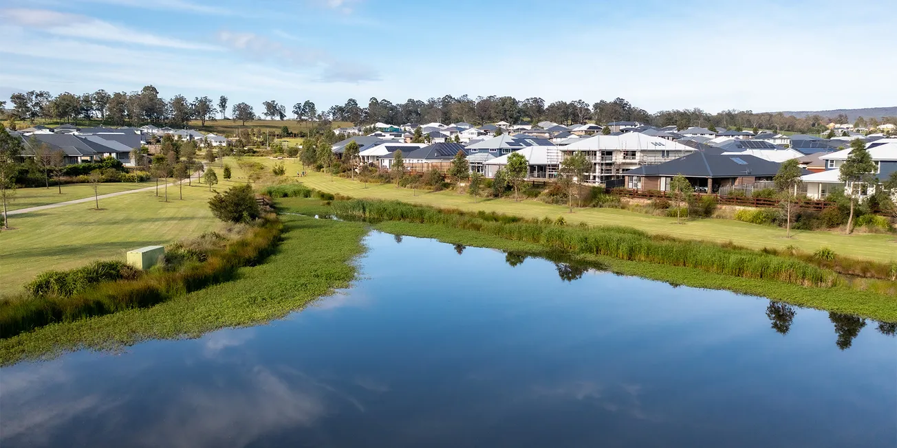
A new vision for the Redbank Expansion Area in North Richmond has put the spotlight on what some are calling a benchmark in green space planning for suburban development.
Proposed by Redbank Communities, the 35-hectare site at Kemsley Park could deliver up to 350 homes while setting aside a substantial proportion of land for public parkland, woodland conservation, and green infrastructure. The headline figure: up to 30–35% of the site retained as green space, a significantly higher ratio than many comparable estates across New South Wales.
While the planning documents list 4.8 hectares (13.7%) for formal parkland and environmental conservation, further green corridors, riparian buffers, tree-lined streets and water-sensitive open space design collectively push the figure much higher.
Behind this achievement is landscape architect-led subdivision design, backed by a community development team and a deliberate focus on heritage-sensitive planning.
These elements have not only preserved key environmental and visual features of the site but also helped shape a best-practice network of linked green spaces.
“Rather than isolated pockets of open space, the Redbank Expansion master plan features connected parks, trails, footpaths and cycleways designed to support use by people of all ages and abilities. The plan includes a central neighbourhood park, a hilltop lookout with views to the Blue Mountains, and a series of green corridors woven through the development. Every home is within 400 metres of public open space.”
The integration of green and blue* infrastructure also helps tackle pressing urban issues: climate resilience, walkability, and mental wellbeing. With extreme heat events becoming more frequent in Western Sydney, planners say preserving canopy cover, enhancing biodiversity, and creating shady public corridors isn’t a luxury—it’s a necessity.
The proposed development is consistent with Hawkesbury City Council’s Urban Greening Strategy, which aims for a 40% tree canopy target, and contributes directly to housing supply targets under the NSW Housing Package and the National Housing Accord. Hawkesbury’s 40% figure falls within the ambitious-plus range for green infrastructural coverage, given that Greater Sydney’s overall tree canopy was about 22% in 2022.
*Blue infrastructure refers to all the water-related infrastructure and natural or engineered features that manage, conserve, or utilize water resources in urban and rural environments.
Urban Design 101: Why Green Space and Connectivity Matter
Urban design best practice is not just about how buildings look—it's about how people live, move, and connect with each other and the natural environment. Redbank’s proposed expansion ticks many of the boxes in what planning experts look for. It aligns with NSW housing targets and urban greening goals and offers a mix of lot sizes and housing types to suit a wide range of households. The proposal protects endangered woodlands, improves stormwater management on past practices, and addresses urban heat through green space and canopy cover. Walkable connected neighbourhoods with every home within 400m of public open space; paths for walking and cycling. The open spaces designed to be usable by people of all ages and abilities.
Cultural Inclusion and Redbank
While the existing development showcases the heritage listed farming practices on which Redbank estate is build and acknowledges Darug and Darkinjung Country, the rich history of First Nations life on the banks of the Hawkesbury River is open for further exploration to give Redbank residents the value of 60,000 years of yet to be told history.
What Happens Next?
Hawkesbury City Council will now assess the rezoning application, with community consultation expected as part of the process. If approved, development may begin within five to ten years—bringing new homes, infrastructure investment, and what could become a model for suburban growth that balances housing with health, heritage, and habitat.
“If the water is right, the trees right, and the connections right—this could be a blueprint for how we grow without losing what matters most.”
Why the Redbank Development Matters
The Redbank Expansion isn’t just about North Richmond — it sets a critical benchmark for how future growth in neighbouring areas, including Glossodia, will be planned and assessed. The design principles being proposed — generous green space allocation, connected open space networks, heritage-sensitive planning, and integrated water management — establish a “baseline standard” that other developments will be expected to match or exceed.
For Glossodia, which faces the proposed Jacaranda Development of approximately 185.3 hectares and around 580 residential lots, this benchmark is significant. The project also promises upgraded roads, new community facilities, parklands, and bushland conservation — but without strong planning standards, these ambitions risk being diluted.
If Redbank demonstrates that high housing yields can coexist with substantial canopy cover, accessible public parks, and strong biodiversity outcomes, then Glossodia can push for the same — ensuring growth strengthens, rather than erodes, its unique rural character and liveability.
