
Another big flood is coming at Windsor. How high it gets still depends partly on the NSW Government.
It should add flood tunnels to the Disaster Adaptation Plan it is drafting for the valley and fund a study to determine whether they work.
At Windsor RSL on Wednesday night, the Hawkesbury Business Group showed more than 80 people how the next big one could be lowered. Engineers at Mott MacDonald ran the Reconstruction Authority’s flood model, which simulated six tunnels cut through the sandstone. A 1-in-100 flood at Windsor Bridge fell by 1.77 metres. Mott MacDonald expects about two metres once it designs the tunnel entrances and exits. Our target is more than two.
Every other attempt to reduce flooding has stalled or been ruled out. Raising the Warragamba Dam wall has stalled, and about 30 per cent of the catchment above Windsor already lies below the dam. In February 2020, the dam held back everything that fell above it, yet about 100 homes and 280 manufactured homes in the valley still flooded.
The Government’s flood taskforce tested a channel from Wilberforce to Currency Creek and two diversions at Sackville. The channel reduced a 1-in-100 flood at Windsor by about half a metre. The Sackville diversions provided minimal benefit because the gorge there is tidal and almost at sea level. Both stopped at Sackville, and the gorges and bends below continued to hold back the water. Infrastructure NSW’s 2017 flood strategy rejected the channel and dredging because the costs outweighed the benefits.
The Reconstruction Authority’s page on the new plan lists levees, evacuation roads, warnings, preparedness, and the management of Warragamba Dam, and notes that it is still analysing infrastructure options. A bypass is not included. The Authority’s fact sheet states that 97 per cent of disaster funding goes to recovery and 3 per cent to mitigation.
The Authority’s 2024 flood study describes the Richmond and Windsor floodplain as a bathtub with five taps and one outlet, and confirms that the lower river’s tight bends hold back the water. The tunnels add a second outlet. Three would run 3.4 kilometres to Currency Creek, and three would run 15.5 kilometres to Canoelands, past Wisemans Ferry, where the river sits much lower. Each would be 22 metres diameter.
In Mott MacDonald’s modelling, a 1-in-100 flood at Windsor Bridge drops from 17.3 metres to 15.6. A 1-in-20 flood drops by about a metre. Small floods barely move. This is a plan for the big ones.
At McGraths Hill, a 1-in-100 flood today would affect about 913 homes, and a 1-in-50 about 576. We expect the tunnels to reduce the 1-in-100 there to close to today’s 1-in-50. Mott MacDonald’s map shows water more than a metre lower across the Richmond lowlands, Pitt Town and McGraths Hill, along Cattai Creek, and up South and Eastern creeks through Riverstone, Marsden Park, Schofields and Penrith’s Llandilo and Shanes Park. The Nepean at Penrith barely changes.
Doing nothing has a price, and we already pay it. Hawkesbury City Council’s 2025 floodplain risk management study estimates average annual flood damage across the council area at about $91 million. In March 2024, the council was still rebuilding roads damaged in the 2020–22 floods, at a cost of $177 million. The March 2022 flood reached 13.8 metres at Windsor, a 1-in-20 event, and Hawkesbury residents still lodged nearly 1,000 home insurance claims.
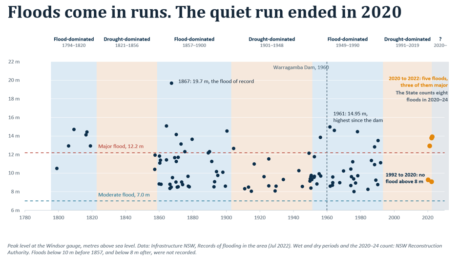
The 2024 flood study indicates that anyone who lives here has a better than 55 per cent chance of experiencing a 1-in-100 flood by the age of 80. It also says that heavier rain from climate change could add 0.9 metres to that flood at Windsor.
The tunnels have downstream costs, and the study must address them openly. The water taken from Windsor goes somewhere. In Mott MacDonald’s modelling, a 1-in-100 flood at Canoelands rises by up to 0.96 metres, and the map shows higher water levels down the river towards Brooklyn and up Mangrove and Berowra creeks. About 1,500 hectares would be affected by upstream flooding, and about 320 hectares that remain dry today would be flooded downstream. People who live there are entitled to see those numbers and to know the study will work to reduce them.
Tunnels for floodwater are not new. Kuala Lumpur’s SMART Tunnel carries floodwater under the city and, when the river is low, carries traffic. Tokyo and Hong Kong also run tunnels that carry floodwater away from their cities. Sydney has built more than 80 kilometres of road and rail tunnel through the same sandstone since 2001 and is finishing another 24 kilometres for Metro West. A study can price the tunnels using real Sydney numbers rather than a guess.
The study would settle how many tunnels, their size and the route. It should design the entrances and exits to get more out of them, cut the rise at Canoelands and price the build properly. It should test the benefits under Infrastructure Australia and Treasury rules, so nobody can say we marked our own homework.
After the presentation, someone asked whether dredging could help while the tunnels are being built. The Government investigated it in 2017. To make a real difference, the river would need to be dredged 10 metres below its bed for 66 kilometres, from Windsor to Wisemans Ferry, and kept that way, because sediment keeps returning. The Government found it cost more than it saved. The study should test it again under the same rules as the tunnels.
On our rough estimate, the study would cost a few million dollars, a small fraction of one year’s flood damage. A business case, an environmental impact assessment, and approvals would follow. That takes years, so it should start now.
Every flood since 2020 has ended with somebody’s life stacked on a Hawkesbury footpath. A few million dollars to find out whether that can change is a bargain.
Hawkesbury should not have to accept that every major flood must be as bad as the last one.
Bob Gribbin, a contributor to the Gazette and a member of the Hawkesbury Business Group, presented its flood tunnel proposal at Windsor RSL on November 4, 2026.


