Long before farms spread across the Hawkesbury floodplain and Windsor and Richmond became colonial towns, this was Aboriginal Country.
For Darug people, also written Dharug, the river, its lagoons, forests and sandstone ridges formed a living landscape of food, ceremony, family connections and responsibility. The wider region also holds deep connections for Darkinjung and Gundungurra peoples.
The history of Aboriginal land rights in the Hawkesbury begins with those enduring relationships, and with the dispossession that followed British settlement.
Along Dyarubbin, the Hawkesbury River, Aboriginal people resisted the occupation of their Country. Between 1794 and 1816, the river became the setting for one of Australia’s longest frontier conflicts. Settlers established crops on river land while Aboriginal people fought to protect their homes and livelihoods.
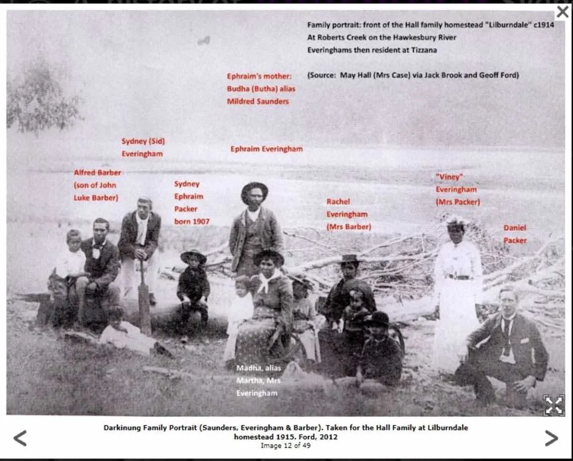
Despite violence, displacement and the removal of children, Aboriginal families remained. Their descendants continue to live on Country today.
Remaining on the river
The story of Sackville Reach demonstrates both the pressure placed on Aboriginal communities and their determination to maintain connections.
In 1889, the government proclaimed the Sackville Reach Aboriginal Reserve in an area where Aboriginal people were already living. A nearby reserve was also established at Kent Reach.
Much of the reserved land was rocky scrub, with only small areas suitable for cultivation. Aboriginal residents worked on surrounding properties, including local farms, while maintaining family and cultural relationships along the river.
The reserve provided a place where people could remain, but within a system administered by the Aborigines Protection Board. Reserving a small portion of Country was a very different arrangement from recognising Aboriginal ownership and authority over ancestral lands.
A movement becomes law
The modern land rights movement sought to address the consequences of dispossession through the return of land and greater Aboriginal control over community futures.
In NSW, a parliamentary select committee appointed in 1978 helped establish the foundations for reform. Its 1980 report described land rights as “an act of elementary justice”.
The NSW Aboriginal Land Rights Act 1983 commenced on 10 June that year. It established a statutory framework through which Aboriginal Land Councils could claim eligible Crown land.
The legislation recognised that land could provide a foundation for cultural, social and economic renewal. Later amendments allowed land councils greater scope to make decisions about their landholdings and community aspirations.
A significant regional organisation emerged in 1984 with the establishment of Mt Druitt Local Aboriginal Land Council. It became Darug Local Aboriginal Land Council in 1986 and Deerubbin Local Aboriginal Land Council in 1996, according to the University of Sydney’s historical timeline.
Land rights and native title
Land rights and native title are often confused, but they are different legal systems.
Under NSW land rights legislation, Aboriginal Land Councils can claim certain Crown land as compensation for historical dispossession. A successful claim generally results in freehold ownership. Establishing traditional connection is not a requirement for that statutory claim.
Native title recognises pre-existing rights and interests arising from traditional laws and customs. It requires evidence of continuing connection and is determined through a separate Commonwealth legal framework.
A land council’s statutory role and a community’s traditional custodianship therefore need to be understood separately.
Recovering the names of Country
Recognition also involves restoring Aboriginal history to the places where it has been obscured.
The Dyarubbin project brought Darug and Darkinjung knowledge-holders together with historian Professor Grace Karskens and other researchers to investigate a list of 178 Aboriginal place names recorded in 1829.
Participants included Leanne Watson, Erin Wilkins, Jasmine Seymour, Rhiannon Wright and Cindy Laws. Their work has helped reconnect names, stories and cultural knowledge with the river landscape.
For Hawkesbury readers, this history adds an essential dimension to the familiar story of colonial farms and towns.
It is also a history of Aboriginal resistance, survival and continuing custodianship and of the long struggle to have those relationships recognised in law and public memory.
Note on public signage
Hawkesbury City Council says its wayfinding project includes Indigenous acknowledgements developed through consultation with Merana Aboriginal Community Association for the Hawkesbury Inc. However, the publicly available project description does not establish whether the traditional place names recovered through the Dyarubbin project have been incorporated into the signs.
The distinction matters. Acknowledging Country and restoring its place names are separate opportunities to recognise the Hawkesbury’s Aboriginal history.
For further information on the Sackville Aboriginal Reserve go to https://www.facebook.com/groups/615137260546546/posts/1167908385269428/